If you are citizen of an European Union member nation, you may not use this service unless you are at least 16 years old.
You already know Dokkio is an AI-powered assistant to organize & manage your digital files & messages. Very soon, Dokkio will support Outlook as well as One Drive. Check it out today!
What is it? The Santa Fe Trail trip is a 12-day camping trip down the historic Santa Fe Trail. We travel in commercial buses and stop at as many sites as we can from Council Grove, KS to Santa Fe, NM. Purpose of Activity: To develop an appreciation of the historical eventsthat occurred during the time of theSanta Fe Trail --1821-1879.
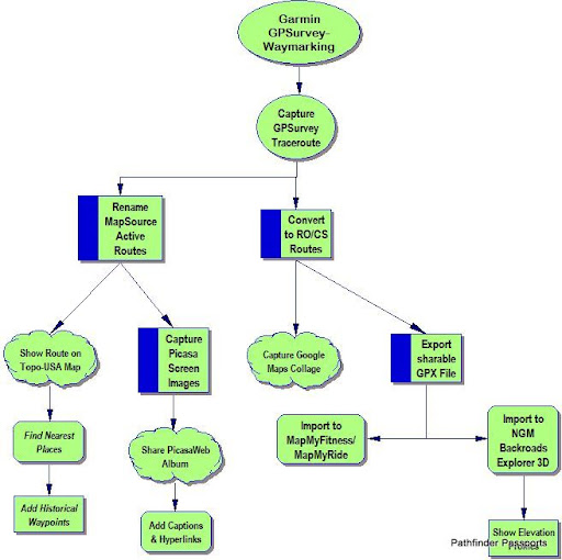
I've used Garmin MapSource/TopoUSA to transfer waypoints from my eTrex-Legend Cx & nuvi-1450 to support Byways of Kansas along K-7 Corridor. It's now designated "Frontier Military Historic Byway"
KVHAdventuring mapXchange(cc) may adopt OpenCache as venue for promoting "Port of Shawnee" River Recreation Area with our Eco-Challenge waymarking learning center at VFW Post 6654 in De Soto, KS.
Posted by: Bob-RJ Burkhart | October 03, 2011 at 09:53 AM
You don't have permission to comment on this page.
 This Wiki is licensed


Comments (2)
Bob-RJ Burkhart said
at 11:53 pm on Nov 6, 2016
Also see Monticello Twp (JoCoGov) to WakarUSA Twp (DGCty) :: http://www.alltrails.com/explore/recording/partners-in-patriotism-tales
Bob-RJ Burkhart said
at 8:53 am on Oct 3, 2011
I've used Garmin MapSource/TopoUSA to transfer waypoints from my eTrex-Legend Cx & nuvi-1450 to support Byways of Kansas along K-7 Corridor. It's now designated "Frontier Military Historic Byway"
KVHAdventuring mapXchange(cc) may adopt OpenCache as venue for promoting "Port of Shawnee" River Recreation Area with our Eco-Challenge waymarking learning center at VFW Post 6654 in De Soto, KS.
Posted by: Bob-RJ Burkhart | October 03, 2011 at 09:53 AM
You don't have permission to comment on this page.