 Prairie-Passage_Eco-Futures-Forum_8n09MSW.pdf

 ... Disaster assistance
- Loading...
- No images or files uploaded yet.
 This Wiki is licensed CC-BY-NC-SA - Creative Commons This Wiki is licensed CC-BY-NC-SA - Creative Commons
Attribution-Noncommercial-Share Alike 3.0 License. Authors, learn more about your rights. Geomorphology : The human role in changing river channels ...Answers to questions about the human role in changing river channels in specific places are still required to understand why change occurred ... linkinghub.elsevier.com/retrieve/pii/S0169555X06002509 - Similar pages
Rivers are both byways and barriers.To understand history, first understand rivers.Learn more about New Santa Fe Frontiers ...
DELOS is an initiative funded by the European Commission'sInformation Society Technologies 5th Framework Programme (IST-FP5). ISBN: 0-8478-2492-6Maps are sometimes even the cause of warfare.
GIS PPT insert object:"Google Earth" "visual learning" mapping thinking
Representing the Republicby John Rennie Short ...
Open Society Institute and Soros Foundation Network
A Valley on Deerskin - An Aztec Map (c. 1600)Timeline - Blended Visual Learningabout Freedom of Influence ...
1589 - Maris Pacifici by Abraham Ortelius (Father of modern cartography)
1688 - Le Nouveau Mexique by Coronelli / Nolin (Copied Penalosa's 1668 Map)
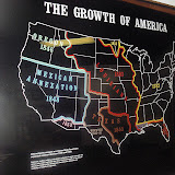
1755 - British & French Dominions in North America by John Mitchell
1795 to 1805:
"We shall delineate with correctness the great arteries (rivers) of this great country: those who come after us will . . . fill up the canvas we begin." --Thomas Jefferson, 1805
1806 to 1816:
Note: What caused Trails-n-Tales(cc) publishing time lags after completing these expeditions?Each graphic guided or influenced subsequent ecomomic and socio-political developments.
Web Resources:
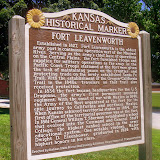
The coolest geography tool I have ever used! And it's free! the U. S. Army's Frontier Army Museum at Leavenworth, and the U. S. Army Center ...
Beyond Lewis and Clark: The Army Explores the WestThis online exhibit addresses military explorers from Lewis and Clark (1804) to George Custer (1874). It is the result of a partnership between the Kansas State Historical Society (KSHS), the Virginia and Washington State historical societies, the U. S. Army's Frontier Army Museum at Leavenworth, and the U. S. Army Center of Military History.
Plus United States Exploring Expedition (1838-1842)
from "Narrative of the United States Exploring Expedition." Philadelphia: 1845 Library of Congress: http://www.loc.gov/exhibits/lewisandclark/lewis-after.html
Frontier Army Museum (USPS 66027)
July 1, 2003 - December 30, 2003 - Richmond (VA)
Beyond Lewis & Clark: The Army Explores the West at the Virginia Historical Society, 428 North Boulevard. To commemorate the bicentennial of the Louisiana Purchase by President Thomas Jefferson and the subsequent Lewis and Clark expedition, the Virginia Historical Society will be the opening venue for this important exhibition, a collaborative effort with the Kansas and Washington State historical societies, the U.S. Army's Frontier Army Museum, and the U.S. Army Center of Military History.
The Lewis and Clark expedition inaugurated a half century of western exploration led by the US Army, in which Meriwether Lewis and William Clark served as captains. Other expeditions were led by such renowned figures as Zebulon Pike and John C. Fremont. Moreover, in the decades before the Civil War, the army was the federal government's "public works department."
It identified the basic network of trails, surveyed the western topography, and laid the groundwork for roads and railroads. As this exhibit will make clear, it is impossible to overstate the role of the army in this critical period of national development.
The U.S. Army Engineer Museum has this mission: Collecting, preserving, and interpreting American military engineering material culture.
|
|
ART REVIEW; Manifest Destiny: Moving West With Maps and Entertainment |
''Heading West: Mapping the Territory'' and ''Touring West: 19th-Century Performing Artists on the Oregon Trail'' take real estate and entertainment back to Square 1, providing sobering insights into our own corporate-driven, celebrity-crazed times and their racial and economic inequities.
|
FHWA > HEP > Environment > Natural > Vegetation > Roadsides 5 Prairie demonstration sites ... - Cached - Similar pages |
FHWA, 2005. “Hey Flaggers: Heads Up!” poster. Kansas LTAP, 2006.
Prairie Passage in Kansas brochure. Kansas DOT, 2005. ...
www.kutc.ku.edu/cgiwrap/kutc/download.php?name=KUTCFall2005.pdf - Similar pages
|
FHWA > HEP > Environment > Natural > Vegetation > Roadsides ... Nearly fifty percent of funds for the prairie passage in Kansas are devoted to educating ...
|
| I'm NOW championing the "Prairie Passage in Kansas" using virtual team tactics ... Collaboratory (LLC) examples of emerging http://FutureThought.org ... - Cached - Similar pages - |
... of the western territories and performing artists in those territories, respectively. ... |
An Association for the Study of Alternative Futures ...An Experimental WIKI |
Travel Restrictions: Kansas, Missouri. Availability: Call for dates – we usually ... |
... Five Regions of the Future; Futurethought Trails-n-Tails Wiki ... - Cached - Similar pages - Note this |
|
aka Prairie Passage in Kansas)... Campus Futures . ... Five Regions of the Future; Futurethought Trails-n-Tails Wiki; wikkipedia geoWIZard Profile ...
|
|
ALL-WinWin "MentorshipART" of Peace |
Relevance: 100.0% - -
Relevance: 100.0% - -
Thought leader is a buzzword or article of jargon used to describe a futurist or person who is recognized among their peer_mentors for innovative_ideas and demonstrates the confidence to promote or share those ideas as actionable distilled insights (thinklets).
in a planned way to accomplish the leaders agenda. Phil Cosby[3]
Heartland Circle Thought Leader Gatherings "A Community of Practice for the New Leader."
Retrieved from "http://en.wikipedia.org/wiki/Thought_leader"
Bob RJ Burkhart![]()
Create Your Badge
![]()
![]() View Bob-RJ Burkhart's profile
View Bob-RJ Burkhart's profile
This work is licensed under a
Creative Commons Attribution-NonCommercial-ShareAlike 4.0 International License.

Comments (3)
Bob-RJ Burkhart said
at 3:45 pm on Mar 23, 2017
Freedom's Frontier National Heritage Area Management Plan ...
http://www.freedomsfrontier.org/uploads/resources/appendix%20a.pdf
Breakout Session: Characteristics of a successful Freedoms' Frontier Site. Partners ......
relayed a pretty positive feeling about the Nat Geo team. ...... she has moved her office and set up Destination Management Inc which will oversee the.
Bob-RJ Burkhart said
at 2:27 am on Sep 27, 2014
During KUCE programs since 2006, I’ve analyzed Kansas Territory’s pervasive “elevation awareness deficiency” from over-reliance on cartography without ground-truthing topography. USNPS Trail of Tears map was is a prime counter-example.
http://www.facebook.com/pages/KVHAdventuring-mapXchange/237637086259613?sk=wall
Google Earth’s Brian McClendon grasped implication of this misperception (Fall-2006).
He quickly added a Google Maps “Terrain Tab” showing current digital elevation model contours.
Our Kansas Alliance of Wetlands & Streams (I-70E Chapter) advocated for state-wide DASC-KGS watershed boundary overlays to replicate our JoCoGov-AIMS prototypes for Clear Creek in Monticello Township (2004-06).
Be Aware or BEWARE of cumulative unintended consequences!
My attached fishbone diagram distills an ESP “thinkLet” I got while transiting
the South China Sea during in 1967 as OOD-UW aboard USS Cimarron (AO-22).
That UFO (Unidentified Floating Object) encounter inspire our crew to move CIM’s removable brass & bronze artifacts to Village of Cimarron, NM (1968-69). Yes, the “Santa Fe Trail Lives On” as EarthSea-Keeping/Midwest Mariner sea stories!
It became my retroactive St. Louis Council BSA (1959) Eagle Scout Leadership service project.
Bob-RJ Burkhart said
at 6:39 pm on Jul 4, 2012
Management Trends?
I received an email the other day asking me to speculate on the future of management....... That’s an interesting question. I am sure most gurus out there have their bullet lists. Here are a few of my thoughts on the topic (these are just my pea brained thoughts and not at all scientific - just what I see and feel) via http://bit.ly/NAg69q
You don't have permission to comment on this page.