-
If you are citizen of an European Union member nation, you may not use this service unless you are at least 16 years old.
-
You already know Dokkio is an AI-powered assistant to organize & manage your digital files & messages. Very soon, Dokkio will support Outlook as well as One Drive. Check it out today!
| |
Blanton's Crossing
Page history
last edited
by Bob-RJ Burkhart 11 years, 8 months ago

 This Wiki is licensed CC-BY-NC-SA - Creative Commons This Wiki is licensed CC-BY-NC-SA - Creative Commons
Attribution-Noncommercial-Share Alike 3.0 License. Authors, learn more about your rights.
[PDF]
File Format: PDF/Adobe Acrobat - View as HTML
NAI National Workshop | Las Vegas, Nevada | November 16–20, 2010.
Dreams and Dilemmas: Fort Scott and the Growth of a Nation ...
www.interpnet.com/workshop/download/NAI2010-Program.pdf
Jan 24, 2010 ... A new film- Dreams and Dilemmas: Fort Scott and the Growth of a Nation- began playing in June of 2009. This 23 minute movie highlights Fort ...www.nps.gov/fosc/planyourvisit/interpretivetools.htm - Cached
-
National Park Service: U.S. Department of the Interior National Park Service ...www.nps.gov/fosc/photosmultimedia/multimedia.htm - Cached
-
Jan 19, 2011 ... This page contains references to Fort Scott's role in the ...www.nps.gov/fosc/historyculture/civwar.htm - Cached - Similar
-
[PDF]
File Format: PDF/Adobe Acrobat - Quick ViewDreams and Dilemmas Contest. Stories of Fort Scott National Historic Site ...www.nps.gov/fosc/forteachers/loader.cfm?csModule=security/getfile...
Subscribe to Blog

Thimble of Soil
Book 2 in the Trail of Thread Series.
AUTOGRAPHED BY AUTHOR!
$11.95
Free Shipping!
Images Videos Maps News Blogs Realtime · even more » · New Features | Help | Sign in ...picasaweb.google.com/GeoVenturing - Cached
-
K-State Research and Extension — Douglas County and its Master Gardeners, ... Kanza Chapter OCTA-Trails “ Blanton's Crossing” into Wakarusa Wetlands . ...picasaweb.google.com/115228214267042563679 - Cached
-
[PDF]
File Format: PDF/Adobe Acrobat - Quick ViewNational Heritage Area Map.) Counties included in the Bleeding Kansas ......
Blanton's Crossing, Douglas County, East of. E 1400,. Louisiana Street ...www.freedomsfrontier.org/partners/.../Ch4-Affected%20Environment.pdf
-
[PDF]
File Format: PDF/Adobe Acrobat - Quick Viewhad a strong frontier agricultural culture, and ..... positions in Douglas ...www.freedomsfrontier.org/.../Ch2-Study%20Area%20History%20and%20Contributions.pdf

Feb 14, 2009 ... The Grand Jury of Douglas County met and “returned indictments against .... KansasExploring > Larry Hornbaker > Events > Blanton's Crossing ...wigwags.wordpress.com/category/political-crisis-of-the-1850s/ - Cached - Similar
-
Feb 14, 2009 ... Free-State men wounded Douglas County sheriff Samuel J. Jones when he .... KansasExploring > Larry Hornbaker > Events > Blanton's Crossing ...wigwags.wordpress.com/2009/03/ - Cached - Similar
-
by JAY MONAGHAN - Cited by 79 - Related articleswere a traditional extralegal device used by squatters on the frontier for a ...... At Blanton's Crossing of the Wakarusa, fives miles from town, ...www.questia.com/googleScholar.qst?docId=26983626
-
Area residents gather at Blanton's Crossing for celebration ...www2.ljworld.com/news/2007/apr/ - Cached

Area residents gather at Blanton's Crossing for celebration
By · April 1, 2007 · Comment on this
Several area residents gathered at Blanton's Crossing for a celebration
of the anniversary of Humbolt officially becoming a town.

http://www2.ljworld.com/marketplace/lawrence/businesses/kaw-valley-heritage-alliance/photos/11729/
Preceded by approximately 7 or 8 thousand years of being part of the Wakarusa wetlands, after the end of the most recent ice age. This post-pleistocene era was preceded by a number of other ice ages, going back to the glacial period some 600,000 years ago, which created the wide Wakarusa valley when glaciers reached into Kansas and then melted, flooding and expanding the size of the Wakarusa valley considerably.
Most likely the wetlands have existed ever since, with the 573 acre remnant a mere fraction of the much larger total of wetlands that used to be here, perhaps 13-17,000 acres in extent.
Now we can talk about what the facts are, free of bias, no? Perhaps a discussion of the ecological and economic value of a wetlands in terms of water purification and filtration, habitat and biodiversity creation, migratory species support, and so on?
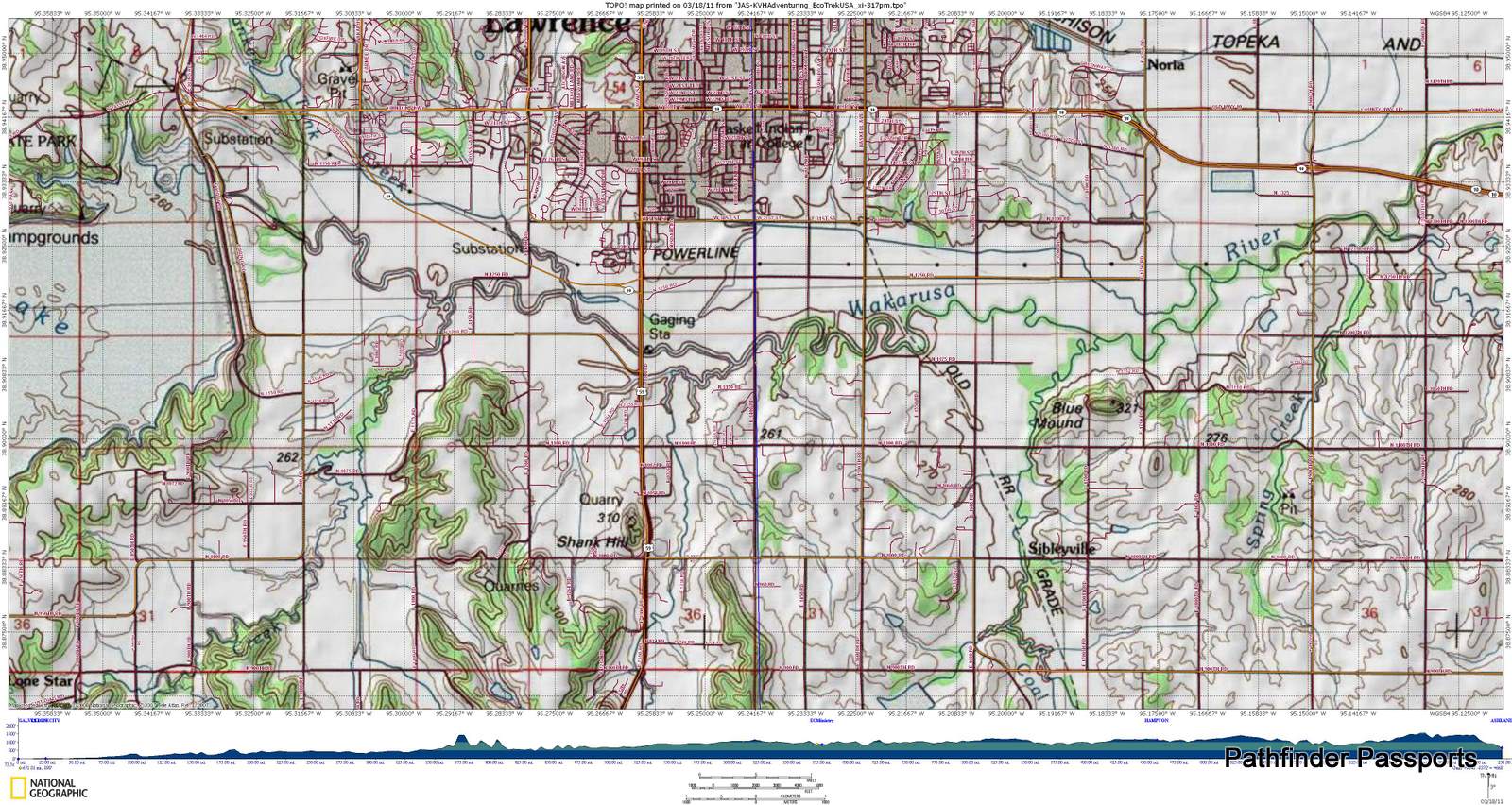
Wakarusa "Blanton's Crossing" Ferry Blanton’s Crossing, Douglas County,
East of E 1400, Louisiana Street extended,Wakarusa River bridge vicinity.
By 1855, Napoleon Bonaparte Blanton had built a toll bridge over the Wakarusa …
- BioGeography
Trails-n-Tales :: Blanton's Crossing | Kaw ... Jun 9, 2010 ...
Trails-n-Tales Eco-Caching mapXchange: ...
Comments JAS-KVHAdventuring (Wakarusa Wetland Learners) ...
- OSU-Mesonet_EndNotes_052406.pdf 1.7 MB
(AEAM): 39. Blanton, B. B. (1998). "The Application of the Cognitive Learning Theory to Instructional Design."
International Journal of Instructional Media 25(2): 171-8. Blewitt, J., and Cullingford, Cedric, Ed. (2004).…
06/22/2007,14:22:07, BLANTONSBR,38.91193,-95.23640,841,06/22/2007,14:21:51,
http://maps.google.com/maps?q=38%2e91193%2c%2d95%2e23640
GARDNER,38.81084,-94.92719,1160,06/22/2007,14:21:59,
- KELP Class
07/13/2009,11:37:23,BLANTONS BRIDGE-FERRY CROSSING
SPRINGWATR,38.95314,-95.23973,873,07/13/2009,12:48:50,
OCTAMARKER,38.95861,-95.25112,1000,07/13/2009,12:50:23,
OCTATRLXNG,38.96521,-95.25994,1033,07/13/2009,12:51…
- On the Loose: Theodore Naish Scout Reservation
07/13/2009,06:37:23,BLANTONS BRIDGE-FERRY CROSSING
SPRINGWATR,38.95314,-95.23973,873,07/13/2009,07:48:50,
OCTAMARKER,38.95861,-95.25112,1000,07/13/2009,07:50:23,
OCTATRLXNG,38.96521,-95.25994,1033,07/13/2009,
- TOPO-GPSurvey_HOAC-BSA-100_9713xm.pdf 716.7 KB
07/13/2009,11:37:23,BLANTONS BRIDGE-FERRY CROSSING …
Cimarron Cutoff 6-0316-6) Greeley, Horace (1860)
An Overland Journey from New York to San Diego in the summer ...
There's a wind farm (built and operated by Florida Power and Light) NE of Montezuma on highway 56
Alcove Springs was a stop along the Oregon Trail near Independence Crossing in Marshall County, Kansas.
Travelers along the trail gave the springs its name. It is located about four miles north of Blue Rapids. Across the road from the Alcove Springs park is another park commemorating the Oregon Trail and features history, wagon swales and a D.A.R. marker memorializing Sarah Keyes, a member of the Donner Party who died in 1846. The exact location of her burial is unknown. Full article
Kaw Valley Landscapes by James R. Shortridge.
University Press of Kansas, 1977, 1988. Kaw Valley Landscapes by James R. Shortridge. ...
en.wikipedia.org/wiki/Hesper,_Kansas - Cached
Hesper is an unincorporated community in Douglas County, Kansas located two and a half miles southeast of Eudora.
Hesper was founded in 1858 by Quakers wanting to lend support to the free-state cause
File Format: PDF/Adobe Acrobat
by H Self - 1990
188 GREAT PLAINS QUARTERLY, SUMMER 1990. Kaw Valley Landscapes.
By James R. Shortridge. Lawrence: University Press of Kansas, 1988. Revised second edition. ...
digitalcommons.unl.edu/cgi/viewcontent.cgi?article=1494&context...
Numerous places are described in detail. Most are small towns and countryside landscapes,
including reservoirs. An amazing historical background is given for each place as well as house
types, barn types, and the land use in most places. The end result gives the viewer an excellent
physical and cultural description of the landscape of each area.
Blanton's Crossing
|
|
Tip: To turn text into a link, highlight the text, then click on a page or file from the list above.
|
|
|
|
|


Comments (2)
Bob-RJ Burkhart said
at 2:43 am on Aug 9, 2012
The Root article I refer to is Nos. 2-7 on your list. The one pertaining to ferries at Topeka is No. 4.
Leon B. Graves
812A SW Fillmore
Topeka KS 66606
(785) 845-8477
leon.graves63@yahoo.com
“Real tolerance means more than just colorblindness and impartiality. It means making an extra effort to get to know and understand your neighbor.”—Justice William J. Brennan, Jr
Bob-RJ Burkhart said
at 3:19 am on Aug 5, 2012
Know Your Watershed Impact Zones (WIZ)
You don't have permission to comment on this page.