
 This Wiki is licensed CC-BY-NC-SA - Creative Commons
Attribution-Noncommercial-Share Alike 3.0 License. Authors, learn more about your rights.
www.esri.com/partners/hardware/why-postprocess.pdfFile Format: PDF/Adobe Acrobat
Trimble, the Globe & Triangle logo, and GPS Pathfinder are trademarks of Trimble Navigation ... to a GIS, the reference frames must be matched, typically ... http://www.ngs.noaa.gov/FGCS/info/sans_SA/ ... (on a point that has been very accurately surveyed), and ... Terrestrial Reference Frame), US Coast Guard beacons ...
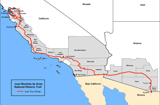
Juan Bautista de Anza National Historic Trail is a 1200 mile trail through Arizona and California.
The route passes through 19 counties and is affiliated with with eight National Park Service sites.
The Anza Trail story is told through countless federal, state, regional, and local agencies, organizations and communities.
Use the Anza Trail Guide to plan your visit. Use the Trailheads webpage to plan a hike or ride.
Or visit the primary Anza Related Sites along the historic corridor.
[PDF]
www.esri.com/library/brochures/pdfs/gis-use-in-map-chart.pdfFile Format: PDF/Adobe Acrobat
requirements, no matter the size of the organization, ... improves data integrity and decreases risk. Using GIS to collect, manage, produce, and ... 8 million square kilometers. australia's coastline (including ..... survey, the portal was created under the Geospatial one- ..... Quality control/Quality assurance by both the GIs team ...

Source: Drawn by Patrick Witmer, based on maps
by Herbert E. Bolton in Anza's California Expeditions.
[PDF]
www.nauticalcharts.noaa.gov/.../Field_Procedures_Manual_May_20...File Format: PDF/Adobe Acrobat
National Oceanic and Atmospheric Administration, Office of Coast Survey. May 2011 ... dated and standardized guidelines and requirements for conducting, processing, and generat- ..... 1.5.2.2.2 Weekly Data Quality Assurance (Weekly DQA) . ...... site approximately weekly to check the physical integrity of the installation.
www.conservationgis.org/links/marine4.htmlNOAA ORCA Coastal Assessment Framework (CAF) is a digital spatial framework ... CA, Land Cover Change CD-ROM, NOAA Searchable Coastal GIS Bibliography . ... the Benthic Surveillance Project, Bioeffects Surveys, the Quality Assurance ... for restoration or preservation data was analyzed using criteria like acreage, ...

Comments (2)
Bob-RJ Burkhart said
at 9:06 am on Jan 30, 2012
How did John C. Fremont's manifest destiny myths influence ethnocide and land abuse decisions?
Bob-RJ Burkhart said
at 7:40 am on Jan 30, 2012
i4CQuest-Keyword Search: Pathfinder Integrity Assurance ESRI GIS NOAA Coast Survey criteria
You don't have permission to comment on this page.