MentorshipART mapXchange(cc) / Palo Flechado Pass
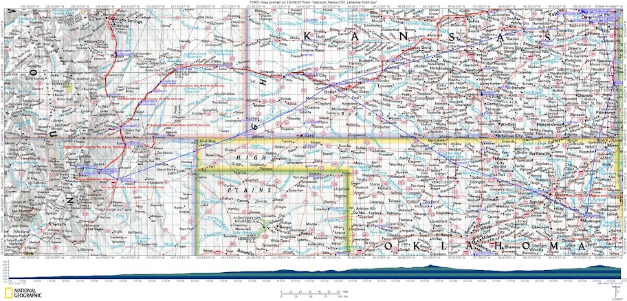
This topographical maps of streams flowing into Eagle Nest Lake
proved helpful in my ongoing BIOgeography research:
This “blended visual learning” courseware prototype served as our interpretation and education planning framework for our USNPS Freedom’s Frontier National Heritage Area (FFNHA). After meeting a key field researcher for Keith Basso’s “Wisdom Sits in Places”, I began analyzing the eco-history of watersheds having Nine-Mile Creek (USGS-GIS) place names!
I suspect it was a Frontier Military Army topographical engineering map-making convention that encoded “Traditional
Ecological Knowledge” (TEK) acquired from land navigation (indigenous nation) scouts via local fur traders aka mountain men!
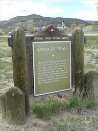
Henry J. Leavenworth brought this mapping convention from the Minnesota Valley (1821) to the Kaw Valley (1827). Both William H. Emory & John C. Fremont seem to have continued this convention while supporting the Army of the West …
Co-locating “E.T.” Seton’s (Grey Wolf) Museum at Philmont Scout Ranch represents an “Affirmation of Interdependence” …
This ALL-WinWin spirit was shared with Cimarron-class “fast fleet oilers” that were commissioned 2-years
after Wade Phillips donated this natural history wildlife refuge to the Boy Scouts of America (BSA) in 1937.
Ernest Thompson Seton ventures out to check his baits, slabs of meat laced with poison. He follows Lobo’s tracks and discovers that Lobo has taken several of the baits. Expecting to find Lobo’s dead body, Seton continues on. At the fourth bait, however, he realizes that Lobo may be smarter than he’d thought.
USS Cimarron was the oldest US Navy ship in continuous active service (1939-1968) due to its Pass Down the Line (PDL) traditions augmented by “lessons learned” from Gospel of the Red Man written aboard RMS Queen Mary during 1936.
Was it coincidence that U.S. Congress ratified the National Historic Trails System Act a day after CIM’s decommissioning?
What other High-TEK Buffalo Spirits (Story Chaser) tales resonate with our honoring eco-history’s corridors of influence?
National Trails System: National Trails System Act
THE NATIONAL TRAILS SYSTEM ACT
(P.L. 90-543, as amended through P.L. 111-11, March 30, 2009)
(also found in United States Code, Volume 16, ...
www.nps.gov/nts/legislation.html
 This Wiki is licensed CC-BY-NC-SA - Creative Commons
Attribution-Noncommercial-Share Alike 3.0 License. Authors, learn more about your rights.
1,517 mi – about 1 day 2 hours
|
  From: From:
|
Lawrence, KS 66046
Change address or drag marker
|

Edit
|
|

|
|
|
|
 Drive: Drive:
|
145 mi – about 2 hours 24 mins
145 mi – about 2 hours 24 mins
|
|

|
1.
|
Head west on N 1175 Rd toward E 1600 Rd
|
1.0 mi
4 mins
|
|

|
2.
|
Turn right to stay on N 1175 Rd
|
0.5 mi
2 mins
|
|
|
3.
|
Turn right at E 1500 Rd
|
1.2 mi
2 mins
|
|

|
4.
|
Turn left at N 1300 Rd/E 31st St
Continue to follow E 31st St
|
2.0 mi
4 mins
|
|
|
5.
|
Turn left at S Iowa St/KS-10/US-59
|
0.5 mi
2 mins
|
|
|
6.
|
Exit onto N 1260 Rd/KS-10
Continue to follow KS-10
|
8.5 mi
9 mins
|
|
|
7.
|
Turn right to merge onto I-70 W/Kansas Turnpike toward Topeka
Continue to follow I-70 W
Partial toll road
|
127 mi
1 hour 52 mins
|
|
|
8.
|
Take exit 253 for Ohio St
|
0.3 mi
|
|
|
9.
|
Turn left at N Ohio Rd/N Ohio St
|
2.9 mi
6 mins
|
|
|
10.
|
Turn right at E Iron Ave
|
0.8 mi
2 mins
|
|
  To: To:
|
Salina, KS
Change address or drag marker
|
Edit
|
|
|
|
|
|
Drive:
|
82.0 mi – about 1 hour 28 mins
82.0 mi – about 1 hour 28 mins
|
|
|
11.
|
Head west on W Iron Ave toward N 7th St
|
0.5 mi
1 min
|
|
|
12.
|
Turn right at N Phillips St
|
381 ft
|
|
|
13.
|
Turn left at W State St
|
1.5 mi
4 mins
|
|
|
14.
|
Turn right to merge onto I-135 N/US-81 N
Continue to follow US-81 N
|
2.4 mi
3 mins
|
|
|
15.
|
Take exit 95B to merge onto I-70 W toward Hays
|
25.5 mi
22 mins
|
|
|
16.
|
Take exit 225 for KS-156 toward Ellsworth/Great Bend
|
0.1 mi
|
|
|
17.
|
Turn left at KS-156
|
47.9 mi
51 mins
|
|
|
18.
|
Slight right toward US-56
|
0.1 mi
|
|
|
19.
|
Slight right at US-56
|
3.7 mi
5 mins
|
|
|
20.
|
Turn right at US-281
|
0.3 mi
2 mins
|
|
To:
|
Great Bend, KS
Change address or drag marker
|
Edit
|
|
|
|
|
|
Drive:
|
23.2 mi – about 30 mins
23.2 mi – about 30 mins
|
|
|
21.
|
Head south on US-281 toward Forest Ave
|
0.3 mi
1 min
|
|
|
22.
|
Turn right at US-56
|
2.5 mi
5 mins
|
|
|
23.
|
Turn left to stay on US-56
|
20.3 mi
23 mins
|
|
|
24.
|
Turn left to stay on US-56
|
194 ft
1 min
|
|
To:
|
Larned, KS
Change address or drag marker
|
Edit
|
|
|
|
|
|
Drive:
|
80.0 mi – about 1 hour 26 mins
80.0 mi – about 1 hour 26 mins
|
|
|
25.
|
Head south on US-56 toward W 13th St
|
56.1 mi
1 hour 0 mins
|
|
|
26.
|
Slight right at US-50 W
|
7.9 mi
10 mins
|
|
|
27.
|
Turn right at US-400/US-50
|
16.0 mi
16 mins
|
|
To:
|
Cimarron, KS
Change address or drag marker
|
Edit
|
|
|
|
|
|
Drive:
|
33.5 mi – about 40 mins
33.5 mi – about 40 mins
|
|
|
28.
|
Head west on US-400/US-50 toward Main St
|
31.3 mi
34 mins
|
|
|
29.
|
Continue on E Fulton St/US-50-BR W
|
1.9 mi
5 mins
|
|
|
30.
|
Turn right at US-50-BR/US-83-BR
|
0.3 mi
1 min
|
|
To:
|
Garden City, KS
Change address or drag marker
|
Edit
|
|
|
|
|
|
Drive:
|
157 mi – about 2 hours 54 mins
157 mi – about 2 hours 54 mins
|
|
|
31.
|
Head north on US-50-BR/US-83-BR toward E Spruce St
|
0.4 mi
1 min
|
|
|
32.
|
Turn left to stay on US-50-BR/US-83-BR
|
0.6 mi
2 mins
|
|
|
33.
|
Turn right to stay on US-50-BR/US-83-BR
|
2.0 mi
4 mins
|
|
|
34.
|
Turn left at US-400/US-50
Continue to follow US-50
Entering Colorado
|
86.4 mi
1 hour 30 mins
|
|
|
35.
|
Turn right at CR-19
|
2.0 mi
3 mins
|
|
|
36.
|
Turn left at CO-196
|
11.3 mi
13 mins
|
|
|
37.
|
Turn right at US-287 N/US-50 W
Continue to follow US-50 W
|
53.7 mi
1 hour 0 mins
|
|
|
38.
|
Turn left at Colorado Ave
|
203 ft
1 min
|
|
To:
|
La Junta, CO
Change address or drag marker
|
Edit
|
|
|
|
|
|
Drive:
|
101 mi – about 2 hours 0 mins
101 mi – about 2 hours 0 mins
|
|
|
39.
|
Head south on Colorado Ave toward E 2nd St
|
0.1 mi
|
|
|
40.
|
Turn right at W 3rd St
|
0.6 mi
2 mins
|
|
|
41.
|
Turn left at Barnes Ave/US-350
Continue to follow US-350
|
78.0 mi
1 hour 32 mins
|
|
|
42.
|
Turn right at Kit Carson Trail/US-350-BYP
|
0.9 mi
2 mins
|
|
|
43.
|
Continue on E Goddard Ave
|
292 ft
|
|
|
44.
|
Turn left to merge onto I-25 S
Entering New Mexico
|
20.6 mi
20 mins
|
|
|
45.
|
Take exit 454 for I-25-BL toward Raton
|
0.2 mi
|
|
|
46.
|
Turn right at I-25-BL
|
1.0 mi
2 mins
|
|
To:
|
Raton, NM
Change address or drag marker
|
Edit
|
|
|
|
|
|
Drive:
|
41.0 mi – about 48 mins
41.0 mi – about 48 mins
|
|
|
47.
|
Head south on N 2nd St toward NM-72
|
2.7 mi
5 mins
|
|
|
48.
|
Take the ramp onto I-25 S
|
3.1 mi
3 mins
|
|
|
49.
|
Take exit 446 for US-64 W toward Taos
|
0.3 mi
|
|
|
50.
|
Merge onto US-64
|
34.8 mi
39 mins
|
|
Drive:
|
35.9 mi – about 52 mins
35.9 mi – about 52 mins
|
|
|
51.
|
Head west on 10th St/US-64 toward N Collinson Ave
Continue to follow US-64
|
33.3 mi
48 mins
|
|
|
52.
|
Turn left at Mountain View Blvd/NM-434
|
2.6 mi
5 mins
|
|
Drive:
|
61.7 mi – about 1 hour 30 mins
61.7 mi – about 1 hour 30 mins
|
|
|
53.
|
Head north on Mountain View Blvd/NM-434 toward Sage Ln
|
2.6 mi
4 mins
|
|
|
54.
|
Turn right at US-64
|
20.8 mi
31 mins
|
|
|
55.
|
Turn left to stay on US-64
|
13.1 mi
19 mins
|
|
|
56.
|
Turn right at NM-58
|
18.8 mi
27 mins
|
|
|
57.
|
Turn right to merge onto I-25 S
|
4.0 mi
4 mins
|
|
|
58.
|
Take exit 414 toward US-56/Springer/US-412/NM-21/NM-468
|
0.2 mi
|
|
|
59.
|
Turn left at Frontage Rd
|
1.0 mi
3 mins
|
|
|
60.
|
Continue on Railroad Ave
|
0.7 mi
1 min
|
|
|
61.
|
Slight right at Maxwell Ave
|
0.3 mi
|
|
|
62.
|
Turn right at NM-21
|
187 ft
|
|
To:
|
Springer, NM
Change address or drag marker
|
Edit
|
|
|
|
|
|
Drive:
|
149 mi – about 2 hours 10 mins
149 mi – about 2 hours 10 mins
|
|
|
63.
|
Head east on NM-21 toward Maxwell Ave
|
187 ft
|
|
|
64.
|
Turn right at Maxwell Ave
|
0.3 mi
2 mins
|
|
|
65.
|
Continue on US-85
|
0.6 mi
1 min
|
|
|
66.
|
Slight right to merge onto I-25 N
Entering Colorado
|
146 mi
2 hours 2 mins
|
|
|
67.
|
Take exit 97B toward Abriendo Ave
|
0.5 mi
|
|
|
68.
|
Merge onto W El Dorado Ave
|
0.1 mi
|
|
|
69.
|
Continue on E Abriendo Ave
|
1.1 mi
3 mins
|
|
|
70.
|
Turn left at W 4th St
|
56 ft
|
|
|
71.
|
Continue on CO-96/Lincoln St
|
0.6 mi
1 min
|
|
To:
|
Pueblo, CO
Change address or drag marker
|
Edit
|
|
|
|
|
|
Drive:
|
260 mi – about 4 hours 3 mins
260 mi – about 4 hours 3 mins
|
|
|
72.
|
Head northeast on CO-96/Lincoln St toward W Adams Ave
Continue to follow CO-96
|
2.1 mi
6 mins
|
|
|
73.
|
Turn left at N Bradford Ave
|
335 ft
1 min
|
|
|
74.
|
Take the ramp onto I-25 N
|
39.6 mi
34 mins
|
|
|
75.
|
Take exit 139 to merge onto US-24 E toward Limon
|
6.6 mi
9 mins
|
|
|
76.
|
Take the exit onto US-24 E
|
66.5 mi
1 hour 7 mins
|
|
|
77.
|
Take the exit onto I-70 E
Entering Kansas
|
136 mi
1 hour 53 mins
|
|
|
78.
|
Take exit 45 for US-24 toward Levant
|
0.2 mi
|
|
|
79.
|
Turn left at US-24
|
9.5 mi
14 mins
|
|
To:
|
Colby, KS
Change address or drag marker
|
Edit
|
|
|
|
|
|
Drive:
|
265 mi – about 4 hours 1 min
265 mi – about 4 hours 1 min
|
|
|
80.
|
Head east on US-24 toward N Lake Ave
|
0.5 mi
1 min
|
|
|
81.
|
Turn right at N Country Club Dr/CR-20
Continue to follow N Country Club Dr
|
2.3 mi
6 mins
|
|
|
82.
|
Turn left to merge onto I-70 E
|
247 mi
3 hours 33 mins
|
|
|
83.
|
Take exit 303 for KS-18 E toward Ogden/Manhattan
|
0.2 mi
|
|
|
84.
|
Turn left at KS-18
|
4.9 mi
7 mins
|
|
|
85.
|
Take the ramp onto KS-18 E
|
8.8 mi
11 mins
|
|
|
86.
|
Turn left at S Juliette Ave
|
0.3 mi
1 min
|
|
|
87.
|
Turn right at Houston St
|
0.3 mi
1 min
|
|
|
88.
|
Turn left at S 4th St
|
200 ft
|
|
To:
|
Manhattan, KS
Change address or drag marker
|
Edit
|
|
|
|
|
|
Drive:
|
83.5 mi – about 1 hour 25 mins
83.5 mi – about 1 hour 25 mins
|
|
|
89.
|
Head south on S 4th St toward Houston St
|
0.1 mi
|
|
|
90.
|
Turn left at Pierre St
|
0.3 mi
1 min
|
|
|
91.
|
Continue on KS-177/KS-18
Continue to follow KS-177
|
8.4 mi
11 mins
|
|
|
92.
|
Take the ramp onto I-70 E/US-40 E
Continue to follow I-70 E
Partial toll road
|
71.5 mi
1 hour 4 mins
|
|
|
93.
|
Take exit 202 toward US-59 S/W Lawrence
|
0.2 mi
1 min
|
|
|
94.
|
Merge onto S McDonald Dr
Partial toll road
|
1.2 mi
3 mins
|
|
|
95.
|
Take the US-40 E/US-59 N ramp
|
0.2 mi
|
|
|
96.
|
Merge onto W 6th St/US-40
|
1.3 mi
2 mins
|
|
|
97.
|
Turn right at Vermont St
|
0.1 mi
|
|
|
98.
|
Turn left at W 7th St
|
0.1 mi
1 min
|
|
|
99.
|
Turn left at New Hampshire St
|
200 ft
|
|
  To: To:
|
Çatalca, KS 66045
Change address or drag marker
|
Edit
|
|
|
|
|


Comments (1)
Bob-RJ Burkhart said
at 6:48 am on Dec 30, 2009
Early U.S. Army/USGS surveying & mapping protocols failed to feature slope & soil type as critical success factors supporting “sustainable land use” decision-making …
Cumulative unintended consequences of manifest destiny (geo-political) “decision traps” combined with influential “extractive economics” vested interests. Together, they compromised sustainable EarthSea-Keeping stewardship practices that Teddy Roosevelt championed …
You don't have permission to comment on this page.